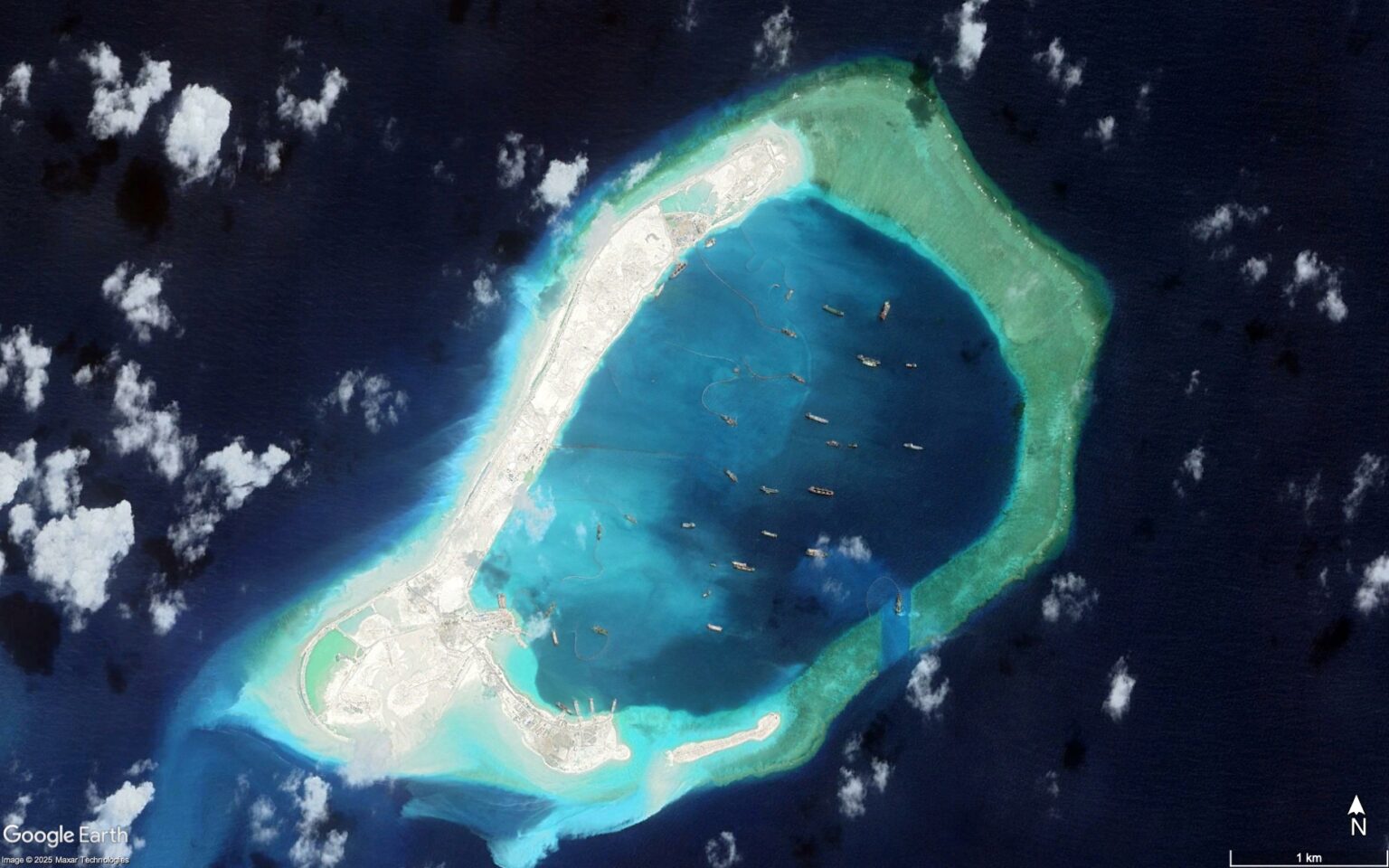
China’s fortified outpost on Subi Reef, one of its largest manmade islands in the South China Sea, is revealed in sharp detail in new satellite images that show expanded infrastructure on the disputed reef.
Subi houses airstrips, radar domes, missile systems and a deepwater port—despite Chinese President Xi Jinping’s 2013 pledge to then-U.S. President Barack Obama not to arm the reefs.
Why It Matters
China claims sovereignty over more than 80 percent of the South China Sea, a stance rejected by a 2016 Hague-based arbitral tribunal ruling that invalidated its sweeping maritime claims. The claims overlap with rival assertions from Vietnam, Malaysia, Taiwan, the Philippines and Brunei.
Subi Reef is one of seven artificial islands China has constructed in the Spratly Island archipelago and one of three it has fully militarized—along with Fiery Cross and Mischief Reef. Chinese maritime forces use Subi as a forward operating hub, and its proximity to the Philippine-held Thitu Island has made it a flashpoint between Beijing and Manila, a U.S. treaty ally.
Newsweek reached out to the Chinese Foreign Ministry by email for comment.
What To Know
China first occupied Subi Reef in 1988. Land reclamation began in 2014 during Beijing’s ambitious dredging campaign in the Spratlys, which peaked that year, and by late 2015 the reef had been transformed into an artificial island of about 1.5 square miles in total area.
According to U.S. Indo-Pacific Commander Admiral John C. Aquilino, China’s military infrastructure on the reef—including radar towers, gun emplacements, missile platforms and reinforced hangars—”appeared to have been completed” by 2022.
“The function of those islands is to expand the offensive capability of the PRC [People’s Republic of China] … They can fly fighters, bombers plus all those offensive capabilities of missile systems,” Aquilino told the Associated Press in 2022. “They threaten all nations who operate in the vicinity and all the international sea and airspace.”
Satellite imagery captured by Maxar provided by Google Earth shows the reef’s transformation over time from orbit. Among the most prominent features are a nearly 10,000-foot runway, aircraft hangars, communications arrays, hardened shelters and docks.
The Hague tribunal’s 2016 ruling under the United Nations Convention on the Law of the Sea classified Subi Reef as a low-tide elevation, not entitled to its own territorial sea or exclusive economic zone. As such, it carries no standing under international law to support sovereign claims.
“Nansha Qundao [the Spratly Islands] have always been China’s territory,” Chinese Foreign Ministry spokesperson Guo Jiakun said during a regular press conference in August. “China firmly opposes relevant countries’ construction activities on islands and reefs they illegally occupy.”
Read the full article here


