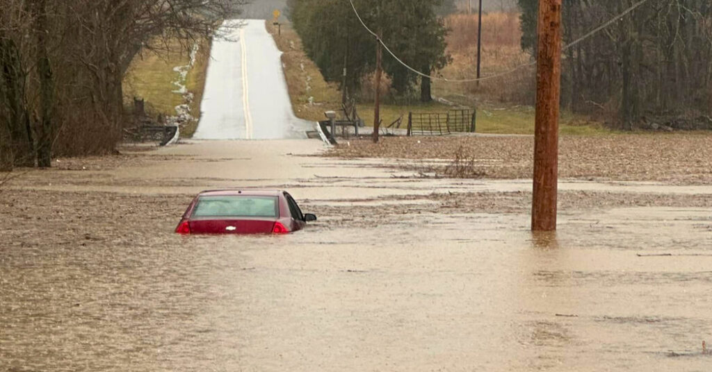
Flood warnings were in place for all 120 counties in Kentucky on Sunday morning, a day after a severe rainstorm pounded a large swath of the South and left at least one person dead.
The National Weather Service issued the warnings for Kentucky on Sunday morning, saying that heavy rainfall from the thunderstorms threatened to trigger flash flooding. While rains had begun to ease, meteorologist Bob Oravec from the National Weather Service said, the warnings would remain in effect since river levels could take time to recede — meaning that the risk of floods would persist.
Parts of Arkansas, Tennessee, Kentucky, West Virginia and Virginia had also been under flood warnings on Saturday, according to the Weather Service. Kentucky was hit particularly hard, with intense rain and wind gusts of up to 60 miles per hour, the service said.
Gov. Andy Beshear of Kentucky said that his state would be under a significant flash flood threat until 4 a.m. local time on Sunday, and that emergency responders were rushing to evacuate Jackson, a small city in the eastern part of the state.
About 30 miles southwest of Jackson, a man was found dead floating in floodwaters in an unincorporated area outside Manchester, Ky., according to Clifton Jones, the chief deputy in the Clay County sheriff’s office.
Jason Abner, the Clay County coroner, identified the man as Donald K. Nicholson, 72, of Manchester, Ky. He said that Mr. Nicholson had been driving on Kentucky Route 80 but got out of his vehicle when the road became impassable, and had been swept several hundred feet.
Governor Beshear wrote on social media that there was “seeing widespread flooding across the state.” Kentucky Route 160 was closed because of a landslide, and water levels in Elizabethtown, in the center of the state, were approaching record highs, Mr. Beshear said. He urged residents to stay off roads.
“Let’s remember to stay alert and be prepared,” Mr. Beshear wrote.
Parts of two dozen state highways were partially or fully flooded, according to the Kentucky State Police. Firefighters and emergency crews rescued people and pets from flooded buildings and stranded cars.
In Virginia, flash floods were reported in the southwestern portion of the state, Gov. Glenn Youngkin said on Saturday. Severe flooding struck Hurley, an unincorporated area near the borders with Kentucky and West Virginia.
In Buchanan County, in western Virginia, emergency teams were rescuing stranded people late Saturday, said Lauren Opett, a spokeswoman for the Virginia Department of Emergency Management.
In western Kentucky, more than six inches of rain had been observed by Sunday morning, the National Weather Service said. Areas of southern Kentucky and northern Tennessee were under a tornado watch until 1 a.m., according to the service.
Tornado warnings were also issued early Sunday for parts of central and northern Georgia, into the northwest of South Carolina, where hail was also expected from the thunderstorms.
More than 240,000 customers were without power in Georgia, and over 160,000 were without power in Alabama early on Sunday, according to Power Outage U.S.
However, Mr. Oravec from the Weather Service warned that the main threat from Sunday’s thunderstorms would be severe winds.
“Gusts between 50 and 60 miles per hour are most likely across northern Florida into Georgia, which may cause trees to fall down and damage to property,” he said.
Even after the cold front carrying the storms moves offshore, strong winds are expected to persist. As a result, wind advisories were issued along the East Coast for Sunday, from northern Florida to the Northeast.
“The storms are going to continue to advance east,” said Frank Pereira, a meteorologist with the Weather Service. “And with that there will be the potential for additional heavy rains and severe weather, including severe thunderstorms and perhaps a tornado or two.”
Judson Jones, Isabella Kwai, Adeel Hassan and Nazaneen Ghaffar contributed reporting.
Read the full article here


