


With the 2026 hurricane season fast approaching, experts say now is the time for households to prepare—reviewing evacuation plans, stocking emergency supplies and checking insurance—with some meteorologists already issuing predictions for how the season could unfold.
The Atlantic hurricane season runs from June 1 through November 30. For the Eastern Pacific, it is from May 15 through November 30.
How to Prepare
“We’re now less than a month away from the start of the Atlantic hurricane season,” AccuWeather lead hurricane expert Alex DaSilva said in an email sent to Newsweek on Monday. “Now is a good time to prepare by checking emergency supplies, updating insurance policies, including flood coverage, and reviewing local evacuation zones and routes.”
Know your risk and evacuation zone
Coastal and inland communities can face different hazards, including storm surge, inland flooding from heavy rain, damaging winds, tornadoes and rip currents, the NWS warns.
The agency recommends knowing whether you live in an evacuation area by checking local emergency management guidance.
Make a plan
NOAA advises planning where you’ll go, with multiple routes, and how you’ll handle pets, and writing down a communication plan in case internet service is limited.
Gather supplies before shelves empty
NOAA recommends assembling disaster supplies with at least a three-day minimum of food, water and medicine, plus items like flashlights, a battery-powered radio, cash and phone charging options.
Check insurance and strengthen your home
NOAA suggests an insurance review (noting flood coverage is typically separate) and documenting possessions ahead of time, along with practical home steps like trimming trees and adding storm shutters or impact protection.
“Remember, the garage door is the most vulnerable part of the home, so it must be able to withstand hurricane-force winds,” it says on its website.
What to Expect
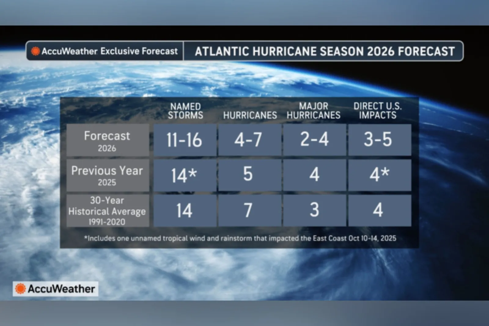
In its forecast for the upcoming Atlantic season, private weather company AccuWeather is currently predicting 11-16 named storms and 4-7 hurricanes. Of these, 2-4 could become major hurricanes (Category 3 and above on the Saffir-Simpson Hurricane Wind Scale), it said. It also estimated 3-5 direct U.S. impacts. DaSilva told Newsweek that the outlet would likely release another update around June 1.
The National Hurricane Center—the arm of the NOAA/National Weather Service responsible for monitoring and forecasting tropical weather systems—is expected to release its outlook this month.
DaSilva told Newsweek that the main driver shaping this year’s forecast is En Niño.
“How strong it gets will have major implications on the season,” he said.
El Niño—associated with warmer Pacific Ocean waters—and La Niña, its cooler counterpart, are alternating phases of the El Niño-Southern Oscillation, a key driver of global weather patterns. This year, experts say a particularly strong “super” El Niño is possible.
“El Niño conditions are associated with fewer tropical storms and hurricanes, especially in the western Atlantic Ocean Basin,” Matthew Rosencrans, NOAA’s lead for its seasonal hurricane outlook, told Newsweek. “El Niño conditions are associated with more tropical storm and hurricane activity during the eastern and central Pacific hurricane seasons.”
Another factor that could shape the season is the Bermuda High, a pressure system that sits over the Atlantic during the summer and plays a role in steering hurricanes, according to NASA. Its position and strength influence storm tracks by acting as a barrier, with a typical setup often guiding hurricanes northward along the East Coast before they turn back out to sea.
DaSilva said the Bermuda High is expected to sit slightly farther east this year, similar to last season, which could lead many storms to curve away from the U.S.
However, he cautioned that some systems may still track close enough to bring impacts, pointing to Hurricane Erin last year, which approached the U.S. coastline but did not make landfall. He said a similar pattern could develop again this season.
“Places like Puerto Rico, U.S. Virgin Islands are going to have to watch out very carefully because as storms start to recurve, they could be close to those islands,” DaSilva said. “I’m concerned about the northern and northeastern Gulf Coast, as well as the North Carolina coast down to about the border of South Carolina.”
DaSilva also said that the central and southern Texas coastline is likely to face a lower-than-average risk of significant hurricane impacts this season.
“That doesn’t mean no risk, but just given the steering patterns, these areas can be a little bit lower,” he said.
AccuWeather has also issued a forecast for the Central and Eastern Pacific hurricane seasons.
Its experts “are forecasting an active 2026 Eastern and Central Pacific hurricane season, warning that exceptionally warm waters and a developing El Niño will raise the risk of direct impacts in Hawaii, far Southern California and parts of Mexico this year,” it said in an email sent to Newsweek on Wednesday.
In the Eastern Pacific, AccuWeather forecasts:
- 17-22 named storms
- 9-13 hurricanes
- 4-8 major hurricanes
- 6-9 direct impacts to Mexico/Central America
In the Central Pacific, it expects:
- 4-7 named storms
- 2-4 hurricanes
- 1-3 major hurricanes
- 1-2 direct impacts to Hawaii
Read the full article here


